Uttarakhand: Panic grips Chamoli village after cracks appear
"Today, Joshimath is on the brink of collapse, Tomorrow, the whole of Uttarakhand will be destroyed," he added.
- Country:
- India
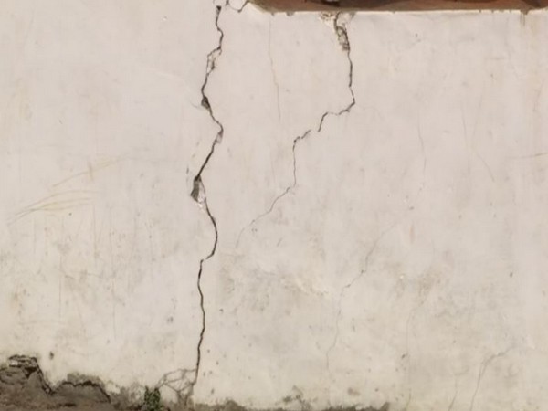
After land subsidence in the Joshimath area of Uttarakhand's Chamoli, cracks have also started to appear in houses in Sharana Chai village of Uttarakhand's Chamoli district. Multiple cracks appeared on houses on Sunday. "Natural calamities like cloud bursts occur more often," Dalip Singh Pawar, one of the residents, said while talking to ANI.
"In case of low magnitude earthquake whole village will be severely affected," said another resident. "Today, Joshimath is on the brink of collapse, tomorrow the whole of Uttarakhand will be destroyed," he added.
Disaster Management Secretary Ranjit Kumar Sinha on Sunday inspected the landslide-affected areas in Uttarakhand's Joshimath and said that there has been an uptick in the number of cracks, but no new areas have faced damages. The Secretary inspected areas including Auli Ropeway, Manohar Bagh, Shankaracharya Math, JP Colony along with geologists and senior officials.
Speaking to ANI, Sinha said that the teams are conducting tests to ascertain if there is any particular pattern of developing cracks. "Relief and rescue operations are being conducted. There has been an uptick in the number of cracks in some places. Cracks haven't developed in new areas. There is a minor increase in the cracks of approx 1 mm but we are monitoring them. We are also finding a pattern so that in the future there is no damage. All teams are conducting tests whether there is any pattern developing of the cracks. After the tests, we will take action based on it. The cracks have increased, but there is nothing to worry about," he said.
"The Central and state governments are making combined efforts during this period. Our all teams have reached here for investigation & now their research will tell what is the reason behind it. After that action will be taken on the same accordingly," Sinha added. He informed that the geophysical study of the affected area is being done by the NGRI Hyderabad. NGRI is studying the underground water channel. After the study, the geophysical and hydrological maps will also be made available by NGRI. These maps will be useful for Joshimath's drainage plan and stabilisation plan. (ANI)
(This story has not been edited by Devdiscourse staff and is auto-generated from a syndicated feed.)
ALSO READ
Lok Sabha elections: Women and Divyang employees to operate polling booths in Uttarakhand
SC raps Uttarakhand State Licensing Authority for not taking action against Patanjali Ayurved in misleading advertisement case.
LS polls: Priyanka Gandhi to hold poll campaign in Uttarakhand's Ramnagar, Roorkee on April 13
Misleading ads case: SC pulls up Uttarakhand government, refuses to accept Patanjali Ayurved's apology
"Last time, they needed a bus, this time a small van only": Uttarakhand CM Dhami jibe at Congress


