Controversy over map in Indore; Pakistan, Bangladesh, others shown as part of India
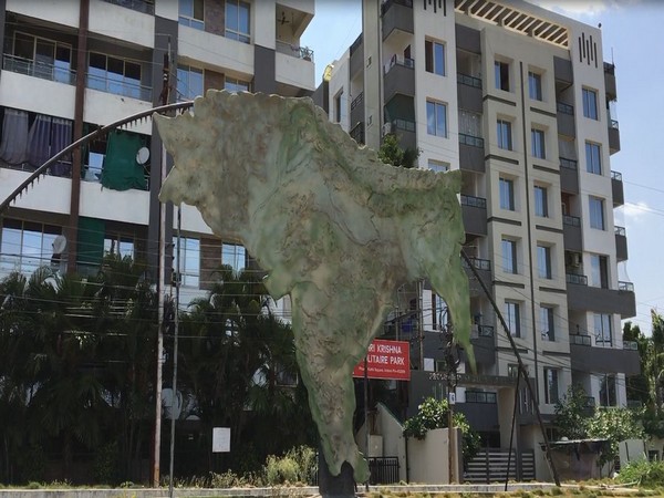
A controversy has erupted over a map installed in Indore's Footi Kothi area in which countries like Pakistan, Bangladesh, Sri Lanka, and Afghanistan are shown as part of India.
- Country:
- India
A controversy has erupted over a map installed in Indore's Footi Kothi area in which countries like Pakistan, Bangladesh, Sri Lanka, and Afghanistan are shown as part of India. Congress has raised objections to the map installed by the Indore Municipal Corporation. The party believes it will have an effect on foreign policy and could lead to friction with other countries.
Speaking to ANI, Congress State Spokesperson Amin Ul Khan Suri said, "The way the Municipal Corporation has prepared the map of Akhand Bharat, we want to ask if there has been a change in the foreign policy. Will there not a conflict be created with the countries which were shown within Indian territory?" The Congress leader alleged that the municipal officials have put up the map "to please their RSS masters".
"The government should clarify what is the purpose behind putting such a map. In this map, the vision of RSS' Akhand Bharat is displayed. It was the dream of Hedgewar. In that order, Afghanistan, Pakistan, Myanmar, Bhutan, Nepal, Burma, Bangladesh, Sri Lanka have been shown as a part of united India. Municipal officers do this to please their RSS masters. Otherwise, if Narendra Modi has big planning in this then he should put it in front of the country," added Suri. Meanwhile, BJP MP Shankar Lalwani said that when India was united, all these countries were on the map.
"This map can be someone's imagination that in future India's form will be as it was the earlier times. I do not know who put the map. But one thing for sure that India's borders were far away in the past," Lalwani told ANI. Sandeep Soni, Additional Commissioner, Indore Municipal Corporation said, "This map is almost two years old. The Footi Kothi square was redeveloped with the theme of the Vedic period, it is during the time the map would have been installed." (ANI)
(This story has not been edited by Devdiscourse staff and is auto-generated from a syndicated feed.)
ALSO READ
UK's Cameron to meet Blinken, Trump while pressing US Congress on Ukraine aid
Saudi Arabia echoes India's stance on Kashmir in joint statement with Pakistan
Pakistan Tehreek-e-Insaf seeks intra-party election certificate from Election Commission
Congress urges Election Commission to permit Vishu-Ramzan fairs in Kerala
Police confirm three fatalities and 20 injuries in two bomb explosions in Pakistan


