Florida battens down ahead of Hurricane Ian
Floridians scrambled to set up sandbags and stockpile emergency supplies on Monday as the state braced for Hurricane Ian, which was expected to bring damaging winds, torrential rains and powerful storm surge later in the week. Residents across the state emptied store shelves of water and household items, as schools and colleges in the Tampa area and northwest Florida canceled classes through at least Thursday.
- Country:
- United States
Floridians scrambled to set up sandbags and stockpile emergency supplies on Monday as the state braced for Hurricane Ian, which was expected to bring damaging winds, torrential rains and powerful storm surge later in the week.
Residents across the state emptied store shelves of water and household items, as schools and colleges in the Tampa area and northwest Florida canceled classes through at least Thursday. The approaching storm also forced NASA on Monday to roll its giant moon rocket off its launchpad in Florida and back to the assembly building to protect the vehicle.
Jose Lugo, who lives in Orange County in the central part of the state, told CNN affiliate WFTV 9 that he made several trips over the weekend to fill up sandbags at a local park for family members. "It’s better to be prepared than sorry later," Lugo said.
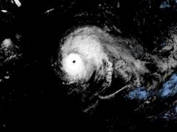
The intensifying storm was about 90 miles (145 km) southwest of Grand Cayman on Monday morning, churning northwest in the Caribbean Sea at 14 miles an hour. Currently with sustained winds of 75 miles per hour (120 km per hour), it was on course to bisect Cuba on Tuesday on its way to Florida, the U.S. National Weather Service said. Ian should intensify once it enters the Gulf of Mexico, mushrooming into a Category 3 storm, but it could weaken again to Category 1, with winds of 90 mph, while parked off Tampa on Florida's Gulf Coast on Thursday, the NHC.
From there, Ian could either make landfall north of Tampa Bay early on Friday or turn northwest toward Florida's Panhandle. Between 6 to 12 inches (15 to 30 cm) of rain will inundate both Florida's Gulf and Atlantic coasts on Thursday, said Bob Oravec, a meteorologist with the National Weather Service's Weather Prediction Center in College Park, Maryland.
"People in Florida should start preparing for this storm now. The sooner the better," said Oravec. "Especially in the Keys and the west coast. In the Keys, there's only one way in or out, if there's an evacuation." Governor Ron DeSantis on Sunday issued an executive order declaring a state of emergency for all 67 counties in Ian's path. He also activated some 2,500 members of the National Guard.
Florida residents were urged to prepare for the potential of catastrophic winds that could damage or destroy homes and businesses and power outages. Flooding from torrential rains could submerge streets and homes, forecasters warned. Ian follows Hurricane Fiona, a powerful Category 4 storm that carved a path of destruction last week through Puerto Rico, leaving most of the U.S. territory without power and potable water. Fiona then barreled through the Turks and Caicos Islands, skirted Bermuda and slammed into Atlantic Canada, where critical infrastructure might take months to repair.
(This story has not been edited by Devdiscourse staff and is auto-generated from a syndicated feed.)
ALSO READ
1 killed, 2 others hospitalised after crane section falls from a South Florida high-rise
Section of crane falls on to bridge in Florida, killing one worker
NASA probes whether object that crashed into Florida home came from space station
Judge warns Giuliani about 'pyrrhic' victory in Florida condo dispute
Gunfight at south Florida bar leaves 2 dead and 7 injured


