Heat wave alert for parts of east, peninsular India over next 2 days
The heat wave is considered if the maximum temperature of a station reaches at least 40 degree Celcius or more for Plains and at least 30 degree Celcius or more for Hilly regions.
- Country:
- India
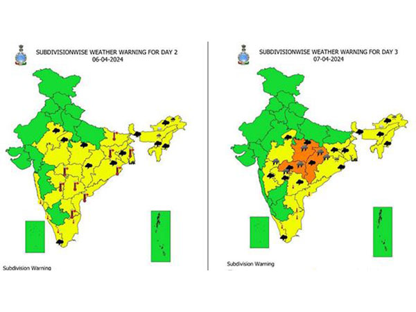
Heat wave conditions are likely to prevail over parts of east and peninsular India during the next two days, the India Meteorological Department said on Friday in its latest update. Regions that would likely see heat waves are Odisha, Gangetic West Bengal, Jharkhand,Vidarbha, North Interior Karnataka, Coastal Andhra Pradesh and Yanam, Rayalaseema and Telangana.
During the past 24 hours, heat wave conditions prevailed in isolated pockets over North Interior Karnataka, Rayalaseema and Coastal Andhra Pradesh and Yanam. Heatwave is a condition of air temperature that becomes fatal to the human body when exposed. It is defined based on the temperature thresholds over a region in terms of actual temperature or its departure from normal.
In certain countries, it is defined in terms of the heat index based on temperature and humidity or based on the extreme percentile of the temperatures. The heat wave is considered if the maximum temperature of a station reaches at least 40 degree Celsius or more for plains and at least 30 degree Celsius or more for Hilly regions.
IMD advised people to avoid heat exposure, wear lightweight, light colour, loose, cotton clothes, cover head, use a cloth, hat or umbrella. On Thursday, maximum temperatures were in the range of 40-42 degree Celcius over many parts of Vidarbha, Telangana and Rayalaseema, some parts of East Uttar Pradesh, Jharkhand, Odisha, Marathwada, Coastal Andhra Pradesh & Yanam and North Interior Karnataka and at isolated pockets over Gangetic West Bengal, Madhya Pradesh, Chhattisgarh, Madhya Maharashtra, Tamil Nadu and Kerala
Maximum temperatures departures are above normal by 3-4 degree Celcius at isolated pockets over Uttar Pradesh, Haryana, East Madhya Pradesh, Odisha, Vidarbha, Jharkhand, Chhattisgarh, Gangetic West Bengal, Rayalaseema, Kerala and Tamil Nadu. Also, an enhanced rainfall and thunderstorm activity is likely to continue over northeastern part of the country till April 9, 2024.
Another Western disturbance is likely to affect Western Himalayan Region from April 10, 2024. Under its influence, light rainfall/snowfall very likely at isolated places over Jammu-Kashmir-Ladakh-Gilgit-Baltistan-Muzaffarabad, Himachal Pradesh on April 5-6, 10-11; and over Uttarakhand during next 7 days. Rainfall at isolated places over Rajasthan very likely on April 5-6, 10-11, 2024, IMD said today.
A cyclonic circulation over north Bangladesh persists, another cyclonic circulation lies over east Assam and neighbourhood. Under its influence, daily widespread to widespread light/moderate rainfall/snowfall with isolated thunderstorms and lightning very likely over Arunachal Pradesh; scattered to fairly widespread light to moderate rainfall with isolated thunderstorms, lightning and gusty winds (40-50 kmph) over Assam and Meghalaya and Nagaland, Manipur, Mizoram and Tripura during next 7 days. (ANI)
(This story has not been edited by Devdiscourse staff and is auto-generated from a syndicated feed.)
ALSO READ
US and Asia allies push for new panel to monitor North Korea sanctions
Envoy Suggests US and Allies Exploring Multiple Options for Monitoring North Korea, Including Actions Beyond the UN
"North East mere liye politics ka nahi, prem aur prathmikta ka vishay hai...": PM Modi
Lockdown lifted at Grand Forks Air Force Base in North Dakota following isolated incident
North Carolina university committee rushes to approve policy change that may lead to reduction in diversity staff


