Monsoon keeps its date with Kerala, heavy rain in several parts of the state; Guj, Maha brace for cyclone
- Country:
- India
The southwest monsoon hit Kerala on Monday on the normal onset date triggering heavy rain in several parts of the state as it marked the commencement of the four-month-long rainfall season that is crucial for the country's farm output and economic growth. The India Meteorological Department(IMD) sounded a red alert in Kozhikode district for two days after Vatakara and Quilandy received 15 cm and 9 cm of rainfall respectively, a bulletin said. A red alert warning indicates the likelihood of extremely heavy rain.
North India is likely to get "above normal" rainfall, while central India and the southern peninsula will receive "normal" rainfall. However, east and northeast India are likely to receive less rainfall than other parts of the country, according to the IMD. The country receives 75 per cent of its rainfall from the southwest monsoon during June to September which is also crucial for replenishing the reservoirs.
“Southwest Monsoon has set in over Kerala today, the 1st June, 2020, coinciding with its normal date," the IMD said in its website, as the southern state recorded widespread rainfall during the past two days. IMD Director General Mrutyunjay Mohapatra also announced the onset of the monsoon.
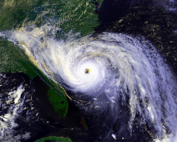
The IMD, meanwhile, warned that a cyclonic storm will cross north Maharashtra and south Gujarat coasts late in the evening on June 3, bringing in its wake heavy rains in parts of the two states and Goa. The Gujarat government has ordered evacuation of people living in low-lying coastal areas and deployed teams of the National Disaster Response Force (NDRF) in over half a dozen districts.
The IMD said the low-pressure area formed over the Arabian Sea has intensified into a depression and it will further intensify into a cyclonic storm in the next 36 hours. Mumbai and its surrounding areas experienced a spell of light rain following a formation of the low pressure area in the Arabian Sea, bringing some respite to the people from the sweltering heat and humidity.
“It(cyclone) will have an impact on Mumbai," Mrutyunjay Mohapatra told PTI. When the cyclonic storm crosses the coast on the evening of June 3, it will have a speed of 105-110 kmph, the IMD said.
When asked by reporters whether the impending cyclone will have any impact on the progress of the southwest monsoon, M Rajeevan, Secretary, Ministry of Earth Sciences, said this will affect its pace. "There will be a slight delay in the advancement of monsoon due to this cyclonic storm," Rajeevan told a media briefing in Delhi on the second long range forecast for the 2020 southwest monsoon rainfall.
Union Home Minister Amit Shah took stock of the preparedness for the impending cyclone at a review meeting in Delhi. The Home Ministry has deployed 23 teams of the NDRF in Maharashtra, Gujarat, Daman and Diu, and Dadra and Nagar Haveli, officials said.
"Union Home Minister @AmitShah held review meeting with senior officials of NDMA, NDRF, IMD & Indian Coast Guard on preparedness for dealing with Cyclone brewing in Arabian sea which is expected to hit some parts of Maharashtra & Gujarat. MoS @nityanandraibjp was also present," Shah's office tweeted. Of the 23 teams of the NDRF, 11 teams were pre-positioned in Gujarat, 10 teams in Maharashtra and two teams in Daman and Diu, and Dadra and Nagar Haveli, the officials said. A team of the NDRF comprises about 45 personnel.
Shah also held a video conference with Chief Ministers of Gujarat and Maharashtra -- Vijay Rupani and Uddhav Thackeray respectively -- and Administrator of Dadra and Nagar Haveli and Daman and Diu, Praful Patel, and assured them of all central help an official statement said. At his briefing, Rajeevan said overall the country will receive normal precipitation with a Long Period Average(LPA) of 102 per cent with an error margin of plus or minus 4 per cent.
In its first long range forecast for monsoon 2020 released in April, the IMD had said the rainfall will be 100 per cent of the LPA. There is 41 per cent possibility that the country will receive "normal" rainfall and just five per cent possibility of "deficient" rainfall, Rajeevan added.
The monthly rainfall over the country as a whole is likely to be 103 per cent of its LPA during July and 97 per cent of LPA during August with a model error of plus or minus 9 per cent. The LPA for the period 1961-2010 is 88 centimetres. LPA between 90-96 per cent is considered as "normal" rainfall. It is considered as "above normal" if the rainfall range is between 104-110 per cent; "excess" if it crosses 110 per cent and "deficient" if it is below 90 per cent.
The IMD has four meteorological subdivisions northwest India, central India, southern peninsula and east and northeast India. The northwest India subdivision comprising states of Himachal Pradesh, Uttarakhand, Punjab, Haryana, Rajasthan, Uttar Pradesh, union territories of Jammu and Kashmir, Ladakh, Delhi and Chandigarh will receive 107 per cent of the rainfall with an error margin of plus or minus 8 per cent. This falls under the "above normal" category.
The central India subdivision will receive 103 per cent of the LPA, which borders the normal and above normal parameter. The central India subdivision covers states of Goa, Maharashtra, Gujarat, Madhya Pradesh, Chhattisgarh and Odisha. The southern peninsula is likely to receive 103 per cent of the LPA. The southern peninsula subdivision consists of Kerala, Puducherry, Tamil Nadu, Karnataka, Andhra Pradesh and Telangana.
However, the east and northeast subdivision will receive 96 per cent of the rainfall which borders the normal and below normal category. This subdivision covers all the northeastern states besides West Bengal, Jharkhand, and Bihar. "Currently, ENSO (El Nino) neutral conditions are prevailing over the equatorial Pacific and neutral IOD (Indian Ocean Dipole) conditions are prevailing over the Indian Ocean.
"Global models indicate cool ENSO conditions are likely to prevail during the monsoon season with some possibility of development of weak La Nina conditions in the later part of the monsoon season," the IMD said. La Nina is associated with cooling of Pacific waters and is believed to have a positive impact on the Indian monsoon. Indian Ocean Dipole is associated with heating (negative IOD) and cooling (positive IOD) of the Indian Ocean waters.
Private forecaster Skymet Weather had on May 30 declared the arrival of monsoon, but the IMD had differed, saying the conditions were not ripe. In Kerala, a Yellow alert (possibility of isolated heavy rainfall) has been issued for Monday in 10 districts and for seven districts on Tuesday, an IMD bulletin said.
Though the state capital Thiruvananthapuram received heavy rains in the morning, by noon it was bright and shiny. Kerala has been receiving heavy pre-monsoon showers since the last few days and shutters of a few dams were opened.
Fishermen have been also warned not to venture into sea and prohibited from fishing activities until further orders. Kerala received unprecedented rains during the previous monsoons in 2018 and 2019, causing massive devastation and claiming hundreds of lives, besides leaving many homeless.
(This story has not been edited by Devdiscourse staff and is auto-generated from a syndicated feed.)
ALSO READ
Eid-ul-Fitr celebrated across Jammu and Kashmir
"BJP will win 25 out of 25 Lok Sabha seats in Rajasthan," says party leader Vijaya Rahatkar
Man electrocuted at Pokhran Railway Station in Rajasthan
Rajasthan: Man waits 22 years for revenge, kills his uncle, burns body to destroy evidence
Will work to strengthen BJP in Rajasthan: Rajendra Gudha


