Western New York eyes weekend deluge of lake-effect snow
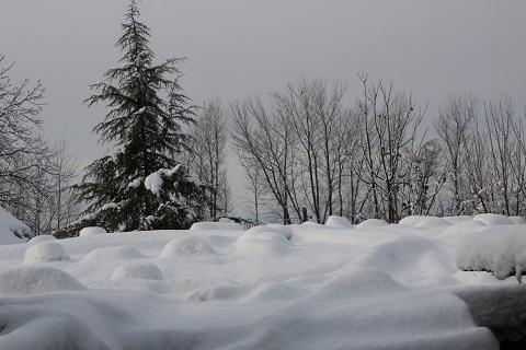
Although the winter season does not officially begin for another five weeks, the National Weather Service posted winter storm warnings, winter weather advisories and lake-effect snow warnings across all western New York areas downwind of the Great Lakes. The weather service said 1 feet to 2 feet (0.3 to 0.6 meter) of snow was expected to pile up in many locations through Sunday, with maximum accumulations likely to exceed 4 feet (1.2 meters) in or near Buffalo, which lies at the eastern end of Lake Erie.
- Country:
- United States
Parts of Western New York state woke up on Friday to nearly 2 feet (0.6 meter) of "lake effect" snow, about half of the total accumulations that forecasters say squalls blowing in from Lake Erie could dump on Buffalo and other cities this weekend.
The squalls could persist through Sunday, creating sporadic bursts of intense snowfall along narrow bands that could amount to 4-1/2 feet (1.4 meters) of snow in some locations. By Friday, the accumulating deep snow had knocked out power to some customers, forced the closure of segments of the New York Thruway and triggered flight cancellations at Buffalo Niagara International Airport.
The prospect of up to 4-1/2 feet of powder on the ground by Sunday prompted the National Football League to move the Buffalo Bills' home game against the Cleveland Browns to Detroit. As of early Friday, road travel bans remained in effect for much of the central part of Erie County.
Officials lifted road restrictions, at least temporarily, and instead issued travel advisories in the northern and southern parts of the county, including Buffalo, where about a foot of snow had fallen. Buffalo is New York state's second most populous city with some 278,000 residents Nearly 6,500 customers were without power in the Buffalo area as of Friday morning, according to Poweroutage.us.
"What we are talking about is a major, major storm," New York Governor Kathy Hochul, said on Thursday, a day after she declared a state of emergency in the Buffalo area. The Buffalo Public Schools district, the state's second-largest serving 32,000 students, canceled all classes and closed offices on Friday.
The storm developed as temperatures for the region, and much of the northern United States, plunged 10 to 20 degrees Fahrenheit below average for this time of year, said Rich Otto, a Storm Prediction Center meteorologist in College Park, Maryland. Although the winter season does not officially begin for another five weeks, the National Weather Service posted winter storm warnings, winter weather advisories and lake-effect snow warnings across all western New York areas downwind of the Great Lakes.
The weather service said 1 feet to 2 feet (0.3 to 0.6 meter) of snow was expected to pile up in many locations through Sunday, with maximum accumulations likely to exceed 4 feet (1.2 meters) in or near Buffalo, which lies at the eastern end of Lake Erie. Those amounts of snowfall are not uncommon for western New York in November, when the relatively warm waters of the Great Lakes can mix with frigid air in the upper atmosphere dropping down from the Arctic, the weather service said.
While the storm was not expected to break weather records, weather service meteorologist Liz Jurkowski said it could rank in the top five snow accumulations over the last 20 years. In November 2014, an epic barrage of lake-effect snow deposited more than 5 feet (1.5 meters) of powder east of Buffalo but dropped just a few inches of snow a few miles to the north, according to the weather service, illustrating the highly localized nature of the phenomenon.
(This story has not been edited by Devdiscourse staff and is auto-generated from a syndicated feed.)
ALSO READ
"New Book 'Get Kids To Play' Sparks Global Movement to Prioritize Play for Children"
Historic collaboration: World Famous King's College now opens its wings in North India in Gurugram
MP CM Shivraj Singh Chouhan sparks debate on 'local vs outsider' in Kamal Nath's stronghold
Lady Gaga spotted with diamond ring in her left hand, sparks engagement rumours
NMC says no new medical colleges, seat increase sanctioned for 24-25 so far, flags 'fake news'


