Atlantic hurricane season 2023: El Nino and extreme Atlantic Ocean heat are about to clash
- Country:
- United States
The Atlantic hurricane season starts on June 1, and forecasters are keeping a close eye on rising ocean temperatures, and not just in the Atlantic.
Globally, warm sea surface temperatures that can fuel hurricanes have been off the charts in the spring of 2023, but what really matters for Atlantic hurricanes are the ocean temperatures in two locations: the North Atlantic basin, where hurricanes are born and intensify, and the eastern-central tropical Pacific Ocean, where El Nino forms.
This year, the two are in conflict – and likely to exert counteracting influences on the crucial conditions that can make or break an Atlantic hurricane season.
The result could be good news for the Caribbean and Atlantic coasts: a near-average hurricane season. But forecasters are warning that that hurricane forecast hinges on El Nino panning out.
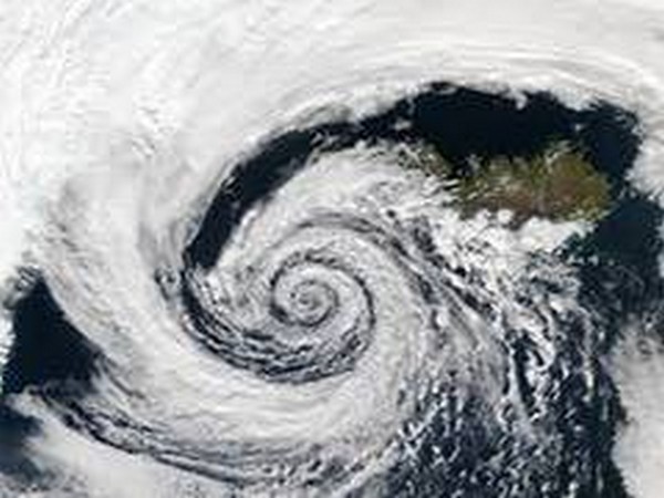
Ingredients of a hurricane In general, hurricanes are more likely to form and intensify when a tropical low-pressure system encounters an environment with warm upper-ocean temperatures, moisture in the atmosphere, instability and weak vertical wind shear.
Warm ocean temperatures provide energy for a hurricane to develop. Vertical wind shear, or the difference in the strength and direction of winds between the lower and upper regions of a tropical storm, disrupts the organisation of convection – the thunderstorms – and brings dry air into the storm, inhibiting its growth.
The Atlantic Ocean’s role is pretty straightforward. Hurricanes draw energy from warm ocean water beneath them. The warmer the ocean temperatures, the better for hurricanes, all else being equal.
Tropical Atlantic Ocean temperatures were unusually warm during the most active Atlantic hurricane seasons on recent record. The 2020 Atlantic hurricane season produced a record 30 named tropical cyclones, while the 2005 Atlantic hurricane season produced 28 named storms, a record 15 of which became hurricanes, including Katrina.
How the Pacific Ocean gets involved The tropical Pacific Ocean’s role in Atlantic hurricane formation is more complicated.
You may be wondering, how can ocean temperatures on the other side of the Americas influence Atlantic hurricanes? The answer lies in teleconnections.
A teleconnection is a chain of processes in which a change in the ocean or atmosphere in one region leads to large-scale changes in atmospheric circulation and temperature that can influence the weather elsewhere.
One recurring pattern of tropical Pacific climate variability that initiates teleconnections is the El Nino-Southern Oscillation.
When the tropical eastern-central Pacific Ocean is unusually warm, El Nino can form. During El Nino events, the warm upper-ocean temperatures change the vertical and east-west atmospheric circulation in the tropics.
That initiates a teleconnection by affecting the east-west winds in the upper atmosphere throughout the tropics, ultimately resulting in stronger vertical wind shear in the Atlantic basin. That wind shear can tamp down hurricanes.
That’s what forecasters are expecting to happen this summer. The latest forecasts show a 90 per cent likelihood that El Nino will develop by August and stay strong through the fall peak of the hurricane season.
A tug of war between Atlantic and Pacific influences My research and work by other atmospheric scientists has shown that a warm Atlantic and a warm tropical Pacific tend to counteract each other, leading to near-average Atlantic hurricane seasons.
Both observations and climate model simulations have shown that outcome. The National Oceanic and Atmospheric Administration’s 2023 forecast calls for a near-average 12 to 17 named storms, five to nine hurricanes and one to four major hurricanes.
An earlier outlook from Colorado State University forecasters anticipates a slightly below-average season, with 13 named storms, compared with a climatological average of 14.4.
The wild cards to watch Although tropical Atlantic and Pacific Ocean temperatures often inform skillful seasonal hurricane forecasts, there are other factors to consider and monitor.
First, will the forecast El Nino and Atlantic warming pan out? If one or the other does not, that could tip the balance in the tug of war between the influences.
The Atlantic Coast should be rooting for El Nino to develop as forecast since such events often reduce hurricane impacts there. If this year’s expected Atlantic Ocean warming were instead paired with La Nina – El Nino’s opposite, characterized by cool tropical Pacific waters – that could have led to a record-breaking active season instead.
Two other factors are also important. The Madden-Julian Oscillation, a pattern of clouds and rainfall that travels eastward through the tropics on a time scale of 30 to 90 days, can either encourage or suppress tropical storm formation. And dust storms from the Saharan air layer, which contains warm, dry and dusty air from Africa, can suppress tropical cyclones.
(This story has not been edited by Devdiscourse staff and is auto-generated from a syndicated feed.)
- READ MORE ON:
- Africa
- Saharan
- National Oceanic and Atmospheric Administration’s
- Americas
- La Nina
- Jun 2
- The Atlantic Ocean’s
- Atlantic Ocean
- Colorado State University
- North Atlantic
- The Atlantic Coast
- Pacific Ocean
- El Nino
- Atlantic
- Katrina
- Pacific
- El Nino’s
- Tropical Atlantic Ocean
- Hurricanes
- The Atlantic Ocean
ALSO READ
Pacific Islands Lead Climate Charge Ahead of COP31
Suraj Estate Developers Limited Acquires Hally Pacific Private Limited with a potential of ~ Rs200 crore GDV project in Prabhadevi
Uniform 15 pc tariff would benefit some Asia-Pacific economies: Moody's Analytics
U.S. Military Takes Down Suspected Narco-Trafficking Vessel in Pacific
Generative AI to Transform Asia Pacific's Corporate Real Estate Landscape


