Cyclone 'Bulbul' to make landfall between WB and B'desh coasts
- Country:
- India
Cyclone 'Bulbul', which has intensified into a very severe cyclonic storm, is likely to make landfall between West Bengal and Bangladesh in the early hours of Sunday, bringing in its wake heavy rain and gusts of up to 135 kmph in the coastal areas, the Met department said. The storm might cause damage to kutcha houses, power and communication lines and roads in parts of the state, Regional Met Director G K Das said, advising people in vulnerable areas to stay indoors.
It might also uproot trees, ruin crops and cause embankment erosion, he warned. According to Das, Kolkata was expected to experience heavy to very heavy rainfall with gusts of up to 70 km per hour on November 9 and 10.
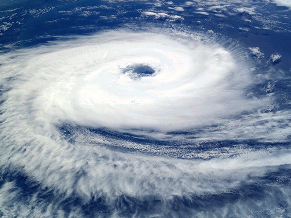
The weatherman said the severe cyclonic storm, which lay centred 600 km south of Kolkata on Friday morning, was expected to intensify further by Saturday and move northwards. "Thereafter, it is very likely to re-curve northeastwards and make landfall between Sagar Islands of West Bengal and Khepupara in Bangladesh across Sunderban delta during the early hours of November 10," Das said.
During landfall, 'Bulbul' is "very likely" to be in the 'severe cyclonic storm' category with maximum sustained windspeed of 110 to 120 km per hour, gusting up to 135 kmph, the regional Met director said. The weatherman has asked the Bengal administration to suspend fishing activities and ferry boat service on November 9 and 10 in Kolkata, North and South 24 Parganas, Howrah, Hooghly, East and West Midnapore districts.
It suggested that coastal hutment dwellers be moved to safer places. The Met also asked tourists in seaside resort towns along the West Bengal coast not to indulge in any water-based activity from the evening of November 8.
According to the IMD, light to moderate rain was likely at many places over the coastal districts of West Bengal on Friday, with heavy rain at one or two areas. The intensity of showers is very likely to increase on November 9 with heavy to very heavy rain at a few places and extremely heavy rain at one or two places in North and South 24 Parganas, East and West Midnapore, Kolkata, Howrah and Hooghly.
The weatherman said that gale wind speed reaching 120 to 130 kmph and gusting to 140 kmph was prevailing over westcentral and adjoining eastcentral Bay of Bengal. "The windspeed is very likely to increase gradually to 145 to 155 kmph, with gusts of up to 170 kmph by early hours of November 9," Das said.
The coastal areas of the state were likely to be hit by 110 to 120 kmph gale wind, with gusts up to 135 kmph from November 9 afternoon, the IMD prediction said Sea condition was expected to hover between very rough and phenomenal during this period, it added..
(This story has not been edited by Devdiscourse staff and is auto-generated from a syndicated feed.)
ALSO READ
Indian Coast Guard strengthens presence in Gujarat
Extreme heat to scorch India during election period, says IMD
Increasing heat unlikely to impact wheat crop, says IMD
Sudden monster waves swallow coastal villages of Thiruvananthapuram
Greece's coast guard says 74 migrants have been found in a wooden boat on the Mediterranean Sea


